Tuesday, January 5, 2010

The Fiducial Mark 2.0

If you read this blog regularly you've probably noticed that the posts have been pretty sparse over the past few months. It's been a busy time, during which I moved back back to my home country of Canada and in doing so, parted ways with ERDAS and joined an exciting new company. I had a fantastic time working at Leica Geosystems / ERDAS for eight years: exploring fascinating technology, traveling across six continents, working with a talented and diverse group of colleagues, and living in locations as diverse as San Diego, Atlanta, and Liege (Belgium). An unforgettable experience!


Now that I'm back on my home turf and we're into a new decade, I've decided to re-launch the blog. While the initial focus of the Fiducial Mark was photogrammetry and mapping with a heavy focus on Leica/ERDAS technology, I plan on shifting gears moving forward. I'd like to use the new site as place to collect thoughts on software product management, geospatial, and social media (and particularly on location-enabled technologies within SM), among other topics of interest.

It's been a blast writing this blog, and I look forward to starting up again. Please feel free to stop by www.fiducialmark.com and say hello!

Tuesday, October 20, 2009

Softcopy Photogrammetry Pricing

It's rare to see any publicity at all around photogrammetry software pricing, so I was surprised to see this post from the All Points Blog:


"I saw a quick demo of Intergraph’s ImageStation which provides image analysts the ability to view in stereo. Intergraph has provided a solution for softcopy photogrammetry for many years. What is different however is the price point. The combination of stereo glasses, a video card using OpenGL technology, a single high-resolution monitor and software will cost under $10K. In the early days of Intergraph's Z/I Imaging softcopy photogrammetry solutions, the price exceeded $100K."

In general I think there has been a downward pricing trend over the past several years, but I also suspect that all the major vendors have "modular" pricing. I doubt the $10K price quoted above would be a full seat (e.g. full range of capabilities) of ImageStation - but if it does it would certainly be a competitive price... It will be interesting to see if and how pricing models evolve as various vendors (hopefully) shift away legacy desktop systems to SaaS and other approaches.

Friday, October 16, 2009

Thoughts on Google Building Maker and 3D Building Extraction

Earlier this week Google introduced the Google Building Maker, which it bills as a simple tool for creating buildings for Google Earth. I gave it a whirl earlier today and while it is a relatively simple toolset, the direction is impressive and has some broad-reaching implications for the future.


The Concept
The general concept is fairly straightforward: using nothing but a browser, you can create a digital 3D representation of building structures using a very basic set of tools. Target buildings are located from a top-down view, and then buildings can be digitized from a series of oblique photos. Several oblique photos can be used to ensure your measurements are accurate from various angles. When you're finished digitizing your target building, you can save it to the Google 3D Warehouse. Upon saving, textures from the various photos are automatically applied to the model. Once the model is uploaded to the 3D Warehouse, you may download it as a KMZ or Collada file.

The Workflow
1) The first step is to launch the Google Building Maker.

2) Once the Building Maker is launched, you have to select a city to extract a model from. At present there are a few dozen cities in the USA, Canada, Mexico, Europe and Japan available. Why can't you extract buildings from your hometown? Most likely because the entire system relies on oblique aerial (not satellite) photography for making 3D measurements. The reason more cities aren't available is because oblique aerial photography is not cheap to acquire: so it makes sense that the currently available cities are clustered in the more prosperous regions of the world. Think hyperlocal advertising...

3) Once you've chosen a city, you are provided with the ability to zoom into a location until you can see a placemark. Once you're at the right zoom level, you can select/drag/drop the placemark to choose the building you wish to model. One interesting aspect of this process is that, in the initial view, you are provided with a color coded graphic overlay of the particular city you want to create a model in. The blue area, typically in the urban core, shows where buildings already exist. The white area shows the areas where Google doesn't have 3D buildings but does have all the ingredients (read: oblique photography) to create them.

Legend: Blue = Buildings Already Exist, White: No Buildings


Selecting an individual building

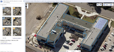
4) After you have dropped a placemark on a building, hit the "Start Building" button on the left. This will switch your perspective from a top-down imagery view to an oblique perspective view. You'll also notice a series of modeling tools on the top right. These include add box, add gable, and add vertical freeform block. There is also a tool for toggling the snapping of points and lines, along with a series of tools for where to place the new block (e.g. above selected, below selected, inline with selected, and unconstrained height). The tools are very rudimentary. For example, it isn't possible to model curves. However, I believe the idea for now is to collect the basic building structure. If it is an easy rectangular building then no further modeling is required, and if it is a complex structure you have the option to "refine your building" in Google SketchUp after hitting the save button. This isn't a particularly slick workflow, but it is fantastic step forward for users without access to photogrammetric tools or other methods for making measurement from photographs.

Perspective View Prior to Building Extraction


Extracted Building

5) Once you've saved your model to the Google 3D Warehouse, you may download it as a KMZ or Collada file. This is a win-win scenario that provides both you and Google with access to your model.

Extracted building in the Google 3D Warehouse

Photo-textured building displayed in Google Earth

The Implications: What Does This Mean???


Personally I think there are a lot of implications for this technology on a number of levels:
  • Photogrammetry Software Vendors: can Building Maker replace proprietary COTS software for 3D feature extraction, such as solutions offered by ERDAS, BAE, and Intergraph (among many others)? In the short-term, no. The current Building Maker tools are simplistic and just scrape the surface in terms of functionality (e.g. no curves, no parallel lines, no attribution, etc). In the long term: Google is certainly setting the stage for a consumer-level system that may one day provide a robust system for 3D urban modeling. In that sense the Building Maker is a very disruptive move by Google.
  • Crowdsourcing: An interesting aspect of the system is that Google denotes the areas they already have buildings for during the selection process. The implicit message for users is: collect buildings that we don't already have (although in fairness there are no restrictions on collecting existing buildings - but why would you?). The other item of note here is that the areas that have oblique coverage that do NOT have buildings already tend to be suburban areas outside the core that consist of low-rise buildings. I can't help but think that this is a clever idea by Google to acquire buildings for free in these areas rather than partner with a professional services company to do the job. But to give Google due credit, they provide users with access to their models. This means that, as a user, I now can use Building Maker to create as many 3D models as I want and then keep the output. And furthermore, I can do this without buying stereo imagery and the software required to perform stereo feature extraction - which can be a significant sum even when considering a small area. As an individual consumer, I now have access to a measurement toolset that was previously only available to professional businesses that had made the requisite investments in both the data and software packages...
  • Is there a partnership between Google and an oblique vendor? Considering that Pictometry is the leading oblique vendor, I can't help but wonder if there is a partnership afoot. One thing to note here is that the oblique imagery is "Copyright 2009 Google".
  • Can this lead to "browser-based photogrammetry"? In recent years I've been a proponent of developing systems that hide the photogrammetry and offer easy-to-use tools to enable 3D geoinformation solutions. I find it quite compelling that this is what Google has come to the plate with: a solution that anyone can use (consumer grade) that makes measurement from aerial photography very easy, and then provides value-added capabilities such as photo-texturing. While 3D feature extraction is only one aspect of photogrammetry, I believe it is a sign of things to come that a giant such as Google has already come to market with a functional solution that many vendors have only been thinking of...
  • 3D measurements from mono imagery were commercialized initially (to my knowledge) by Geotango, which was subsequently acquired by Microsoft. This highlights the nascent competition between Google and Microsoft in this space.
  • As mentioned in the Google Earth Blog, the big limitation is the fact that you have to choose from a list of available cities. One can only wonder what this will do for the oblique airborne photography market...
At any rate, kudos to Google for once again changing the game!

Wednesday, September 23, 2009

Atlanta Flooding: Satellite Images from DigitalGlobe

A colleague passed along a few images of the flooding in Atlanta, which DG provided permission to post. This imagery truly demonstrates the value of satellite imagery and remote sensing in general for crisis / rapid response situations - not to mention how bad the flooding in Atlanta is.

Click on the images below for higher-detail versions.

Six Flags 9/22/09

Satellite Image Credit: DigitalGlobe


Lithia Springs 9/22/09

Satellite Image Credit: DigitalGlobe

3D GIS Seminar

Just a quick note to say that the Bentley Seminar on "Bentley 3D GIS" is now available here. You need to register for both their site and the seminar, but it is quick and painless. The main focus on the seminar is (a) the need for 3D GIS for infrastructure and other applications and, (b) Bentley's tools for integrating GIS, CAD, and BIM data for city modeling applications. This focused on Bentley Map as a primary tool for data integration, modeling, and visualization. CityGML export has been added, which may make Bentley Map one of the earliest systems from a major vendor to support the standard.

It's great to see more people thinking about 3D cities beyond just the physical models. It will be interesting to see who will be the first to market with a system that integrates model creation and collection (e.g. collect buildings in stereo, from LIDAR, or automated techniques) along with urban information management.

Monday, September 21, 2009

Photogrammetry News: Photogrammetric Week 2009

It has been a busy summer and as a result I haven't had much time for keeping up to date with The Fiducial Mark. But with an inter-continental move from Belgium back to Canada wrapped up, there is a lot of news in the mapping business to comment on.


One major event that comes along every couple years is Photogrammetry Week in Stuttgart, Germany. This event, which was held a few weeks ago on September 7-11, is a great forum for learning about the latest developments in airborne sensors, software, and general industry trends. For those of us that didn't get a chance to make it over, the Institute for Photogrammetry at the Universität Stuttgart hosts a web-site containing the agenda, photos, and papers from the conference. The "Papers of the 52nd Photogrammetric Week" section contains a gold-mine of information, and a review of the articles provides a look at where things are at in the industry today.

Papers are divided into four sections:

Introduction: Presentation papers from the University of Stuttgart, Hexagon (Leica Geosystems and ERDAS), Intergraph, Vexcel Imaging (Microsoft), Trimble Geospatial, and IGI. These papers provide company overviews, organizations updates and a common focus on sensor updates (e.g. ADS80, UltraCamXp, etc).

Image-based Data Collection: these papers largely focus on airborne camera systems. One interesting paper is "Digital Airborne Camera Performance - the DGPF Test" by Michael Cramer. DGPF is the German Society of Photogrammetry, Remote Sensing, and Geoinformation. The paper discusses an ongoing project evaluating the strengths and weaknesses of various digital sensors, covering systems from Intergraph, Leica Geosystems, Jenaoptronik, Vexcel Imaging, IGI, Rolleimetric, and DLR Munich. The project involved data collection flights over a well-controlled test site near Stuttgart. In reading the paper, it becomes clear how difficult it is to perform precise apples-to-apples tests between systems - given how many factors can impact the performance of a system (e.g. weather). The paper focuses on geometric accuracy and provides detailed information on the studies conducted thus far. It will be interesting when results are available from the radiometry working group, because this is an area where there are a number of differences between the above sensor systems.

Other interesting papers in this section are "Oblique Aerial Photography: a Status Review", and "The Bright Future of High Resolution Satellite Remote Sensing - Will Aerial Photogrammetry Become Obsolete?" The oblique paper is a good reminder of how Pictometry has come to dominate this particular niche. While I don't believe aerial photogrammetry will become obsolete anytime soon, the second paper raises some great points on the development of satellite-based photogrammetry.

LiDAR: Airborne, Terrestrial and Mobile Applications: numerous papers on both hardware and processing developments for airborne and terrestrial LIDAR applications. The intriguing topic here is how mobile laser scanning is becoming increasingly relevant (Gene Roe adds insight on this topic as well here).

Value-Added Photogrammetry: articles providing a look at where current photogrammetric processing research is focused. The topics range from standards (CityGML), sensor to internet workflows (ERDAS is in a unique position of being the only company that can really offer a solution that starts with data capture and ends up with on-line data delivery and web services), digital image matching, cultural heritage, and more. Automated terrain extraction from stereo imagery is being pursued with renewed vigor, and it is good to see standards appear on the radar as well. Although I failed to see any developments on standards with regards to photogrammetric metadata, it will be great progress if CityGML gains momentum for one of photogrammetry's primary data products: 3D models.

Kudos to the conference organizers for sharing the conference materials - it is a valuable resource and greatly beneficial to the broader geospatial community as well. Sensor data and photogrammetric processing technology is the root of 3D geo-information, and it will only be a matter of time before these technologies embed themselves in an even broader array of applications.

Monday, July 13, 2009

eATE: Automatic Terrain Extraction Webinar

If you're interested in automatic 3D terrain generation technology, please consider participating in our "Terrain from Imagery" webinar tomorrow (11am ET). Details are on the ERDAS homepage and the registration info is here. I'll be discussing some new technology that we've been working on for some time now, and are looking forward to releasing later this year. The webinar will cover a bit of introductory material, and then move into other areas such as point cloud generation (versus TINs and Grids), RGB-encoding, achieving throughput through parallel processing, and an overview of the user interface and some of the results we've generated thus far.

GeoEye-1 Color Terrain: Hobart, Australia